
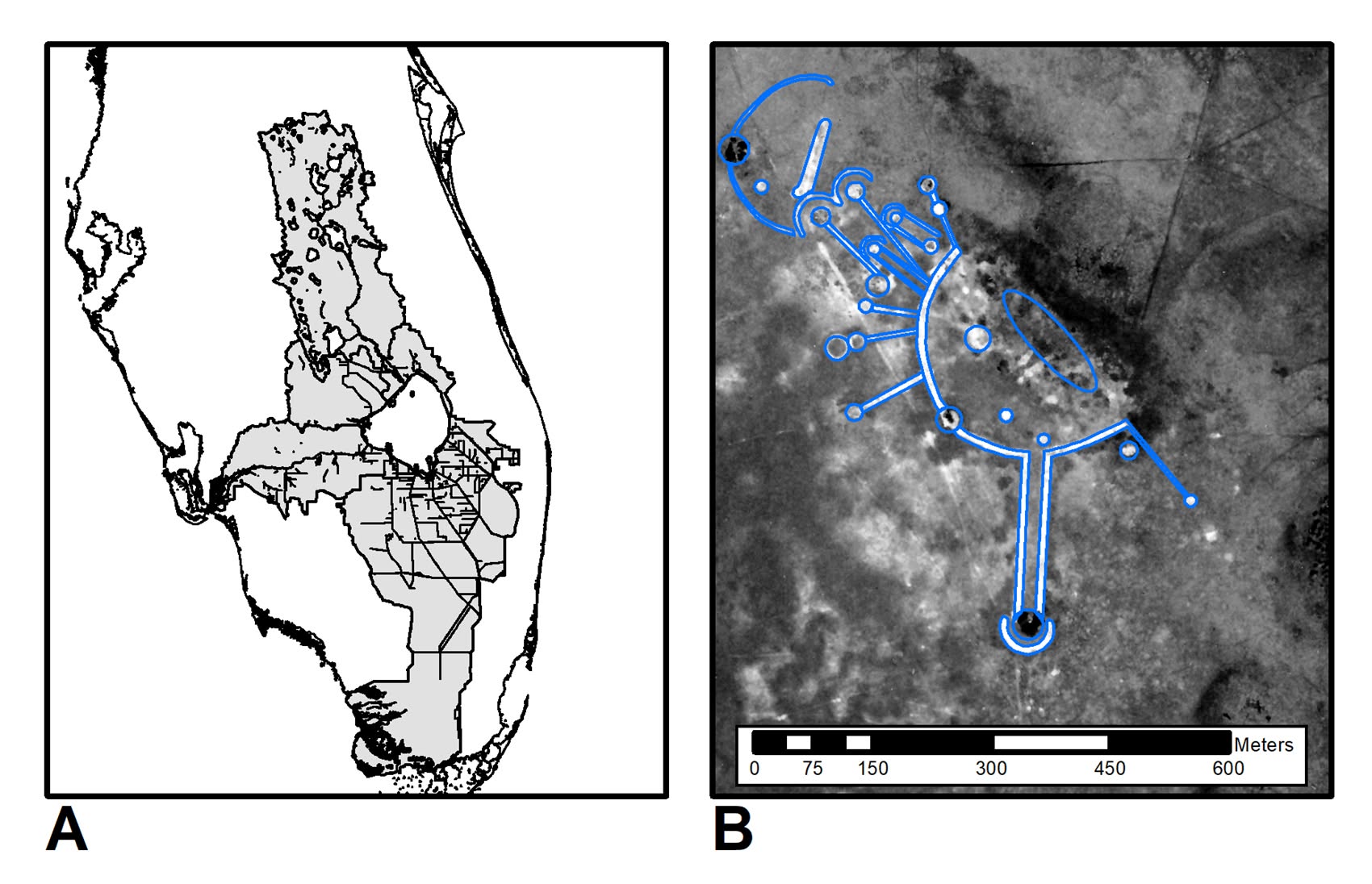
Hidden in the flat wetlands south of Lake Okeechobee is one of Florida’s most remarkable archaeological landscapes, yet many Floridians have never heard its name. Tony’s Mound, also historically called Big Mound Circle, is a monumental Native American earthwork complex in Hendry County south of Clewiston. From the ground, its immense scale can be difficult to comprehend, but viewed from above, the landscape reveals an extraordinary pattern of sweeping curved earthworks, long raised ridges, causeways, mounds, and geometric forms spreading across what was once a vast seasonally flooded world.
The sight is so unusual that, to modern eyes, the enormous circles and radiating lines can almost resemble an ancient Florida version of crop circles. The comparison is only visual, of course: crop circles are temporary patterns pressed into vegetation, while Tony’s Mound and the related earthworks of the Lake Okeechobee region were intentionally constructed monuments created by Native people who moved and shaped earth on a tremendous scale. Their geometry nevertheless creates much the same sense of wonder, because someone deliberately drew immense patterns across the landscape and, thousands of years later, we are still trying to understand everything those patterns meant.
Tony’s Mound belongs to the archaeological tradition generally associated with the Belle Glade culture, whose communities inhabited the Kissimmee River, Lake Okeechobee, and northern Everglades region for roughly two millennia. These communities did not simply occupy the South Florida environment; they understood its seasons, water, wildlife, and geography well enough to build monumental landscapes within it, producing some of the most distinctive earthworks in prehistoric North America.
A 580-Foot Circle Hidden in the Florida Wetlands
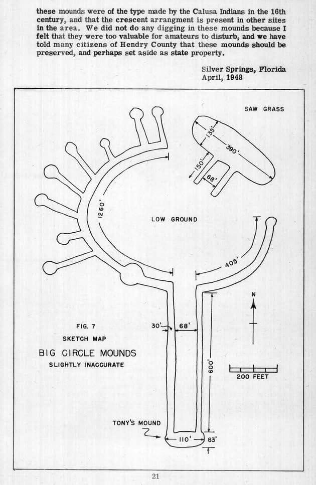
One of the earliest detailed published descriptions of Tony’s Mound came from famed Florida naturalist Ross Allen, who visited the complex in the 1940s. Allen and his expedition reached a place so extensive that he emphasized how difficult it was to appreciate the entire complex from ground level. Aerial photography helped reveal what walking through the grass could not: an enormous organized landscape of raised earthworks.
Allen reported that the great C-shaped or circular earthwork measured approximately 580 feet in diameter, with a circumference of about 1,665 feet. He described roadway-like embankments and raised pathways extending through the complex, while aerial observations showed long causeways radiating from the central area. The result is a landscape that can resemble an enormous wheel, sunburst, or geometric drawing placed directly onto the Florida terrain.
Tony’s Mound at a Glance
- Location: Hendry County, south of Clewiston and Lake Okeechobee.
- Archaeological tradition: Belle Glade cultural region of south-central Florida.
- Great circular earthwork: Reported by Ross Allen at approximately 580 feet in diameter.
- Complex design: Mounds, curved embankments, raised causeways, linear ridges, and open spaces formed a larger engineered landscape.
- Important distinction: The 580-foot measurement describes the great circular earthwork, not a single 580-foot-wide mound.
The site was far more complex than a single mound. Allen described a principal mound measuring approximately 110 by 83 feet, another very large mound roughly 390 feet long and 135 feet wide, canal-like depressions, elevated pathways, and numerous additional earthworks. Some raised features appear to have connected different portions of the complex across terrain that historically experienced prolonged seasonal flooding, so the name “Tony’s Mound” can actually understate what the place represents. It is better understood as an engineered archaeological landscape in which circles, ridges, mounds, causeways, waterways, and open spaces were organized into a much larger whole.
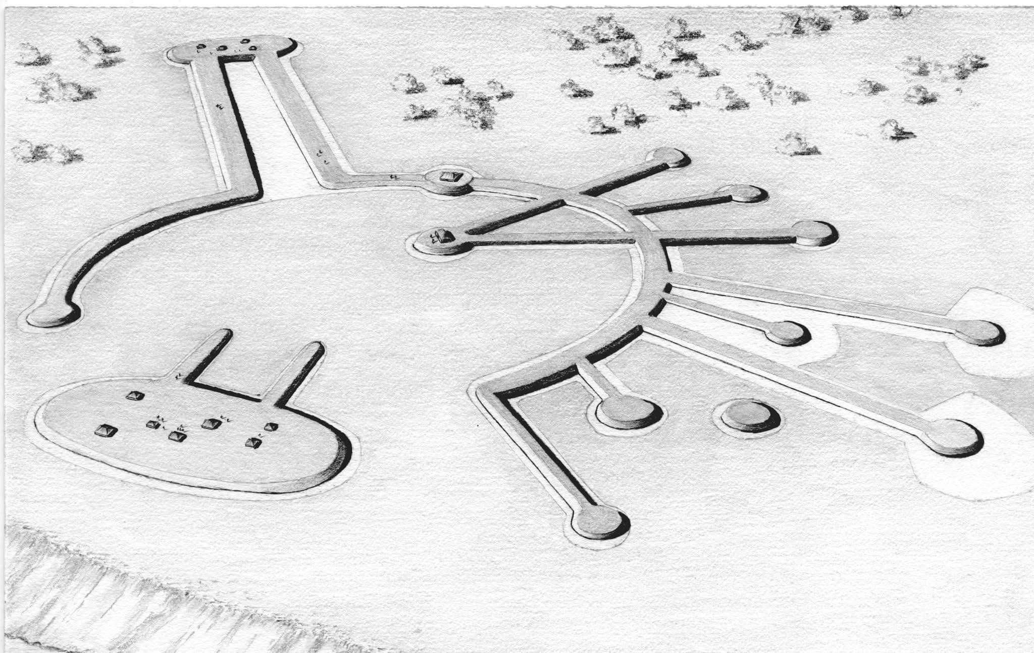
Florida’s Ancient “Crop Circles”
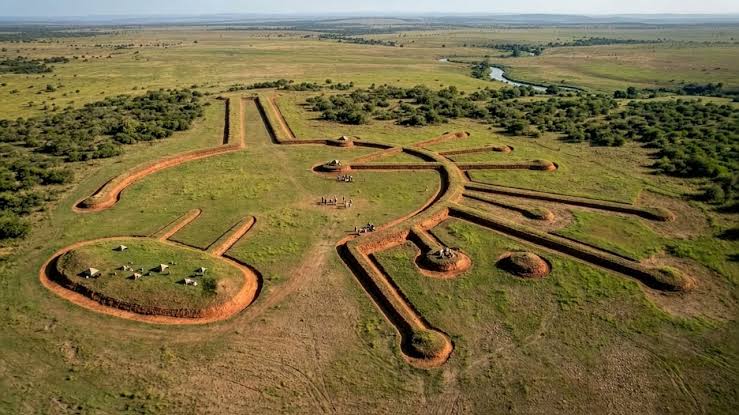
Calling these features ancient “crop circles” is not an archaeological description, but it captures the immediate visual reaction many people have when first seeing maps or aerial reconstructions of Belle Glade earthworks. The landscape contains huge curved forms accompanied by remarkably straight lines extending outward across the surrounding terrain, and at related sites some linear ridges terminate in substantial mounds, producing designs that resemble the spokes of a wheel or rays radiating from the sun.
Archaeologists describe important examples of this architecture as circular-linear earthworks. Tony’s Mound is one of the best-known examples, but it forms part of a broader regional tradition that also includes Big Mound City, Fort Center, the Hendry Earthworks, and other sites within the Okeechobee Basin. Their existence immediately raises questions: why create such enormous geometric shapes, why construct straight ridges at particular angles, why place mounds at their ends, and why expend so much collective labor shaping a landscape where seasonal water could cover much of the surrounding country for months?
Circles, Lines, and the Sky
One of the most intriguing areas of modern research involves the orientations of the linear earthworks themselves. Archaeological research on Belle Glade monumental landscapes has explored relationships between some radiating ridges and recurring celestial events, including positions associated with solstices and equinoxes. The evidence does not mean that every ridge has been proven to function as an astronomical marker, but it does show that the geometry deserves to be studied as more than practical road building.
For people living in the historic Kissimmee-Okeechobee-Everglades watershed, observations of the sky would have been intimately connected with changes taking place on the ground. Seasonal rainfall controlled water levels across an enormous area, while the transition into and out of the wet season affected fish, turtles, mammals, birds, travel routes, dry ground, and virtually every other aspect of life. A ridge associated with a recurring position of the sun could therefore represent much more than an abstract interest in astronomy; it could express connections among the heavens, seasons, water, animals, and human activity, embedding cyclical time into the architecture itself.
The most fascinating mystery is not that the circles exist, but that their builders created landscape-scale geometry in a world where water, seasons, distant places, and the sky may all have been part of the same design.
Lines Toward Other Important Places
The patterns become even more interesting when the earthworks are considered across greater distances. Researchers studying Belle Glade monumental landscapes have explored whether certain linear orientations relate to other important archaeological places, including other earthworks, burial locations, and major Native sites extending across southern Florida. Places discussed in this broader research include Fort Center, Big Mound City, Ortona, Mound Key, and Pineland.
These relationships should not be interpreted as proof that every ridge functioned as a literal road to a distant destination. Instead, they raise the possibility that monumental architecture could encode relationships among important places and communities across the Florida landscape. A straight ridge pointing toward a meaningful place on the horizon could have been both architecture and geography, turning an earthwork into something resembling a physical map of relationships that mattered to the people who created it.
Building Monumental Architecture Without Stone
When modern people imagine ancient monumental architecture, they often think of pyramids, stone temples, defensive walls, or enormous carved monuments. South Florida offered very little suitable stone, so Belle Glade communities created a monumental tradition appropriate to the materials and environmental conditions around them: they built with earth.
Over generations, enormous quantities of sand and soil were moved by human labor to create raised platforms, ridges, causeways, and mounds. Exactly how every portion of Tony’s Mound was constructed is not completely known, so it is better not to present a single method such as “basket-loading” as a proven technique for every feature at this particular site. What cannot reasonably be questioned is the scale of the work. Soil had to be gathered, transported, and deliberately placed, while the repeated geometry of the complexes demonstrates planning rather than random accumulation.
A Civilization Built in a World of Water
The landscape around Lake Okeechobee that we know today is profoundly altered. Before modern drainage, canals, levees, pumps, agriculture, and development transformed South Florida, the Kissimmee-Okeechobee-Everglades watershed was one of the great wetland systems of North America. Water covered portions of this landscape for long periods during seasonal cycles, while tree-island hammocks and other elevated places provided precious areas of dry ground as water rose and receded around them.
Within this watery environment, even small changes in elevation mattered. Raised earthworks could provide usable ground above surrounding wetlands, while causeways could connect areas separated by saturated terrain and waterways could provide transportation and access to aquatic resources. Practical adaptation, however, does not explain everything at Tony’s Mound. The enormous curved forms, carefully oriented linear ridges, and possible relationships with seasonal celestial events and other important places suggest that these landscapes could simultaneously serve practical, social, ceremonial, and cosmological purposes.
Why Has Almost Nobody Heard of Tony’s Mound?
Considering its scale, Tony’s Mound is surprisingly absent from most popular accounts of Florida history. Ask Floridians to name Native archaeological sites and some may know Fort Center, Crystal River, Mound Key, or the great shell works of the Calusa, yet Tony’s Mound remains obscure despite possessing some of the most visually remarkable earthworks in the state.
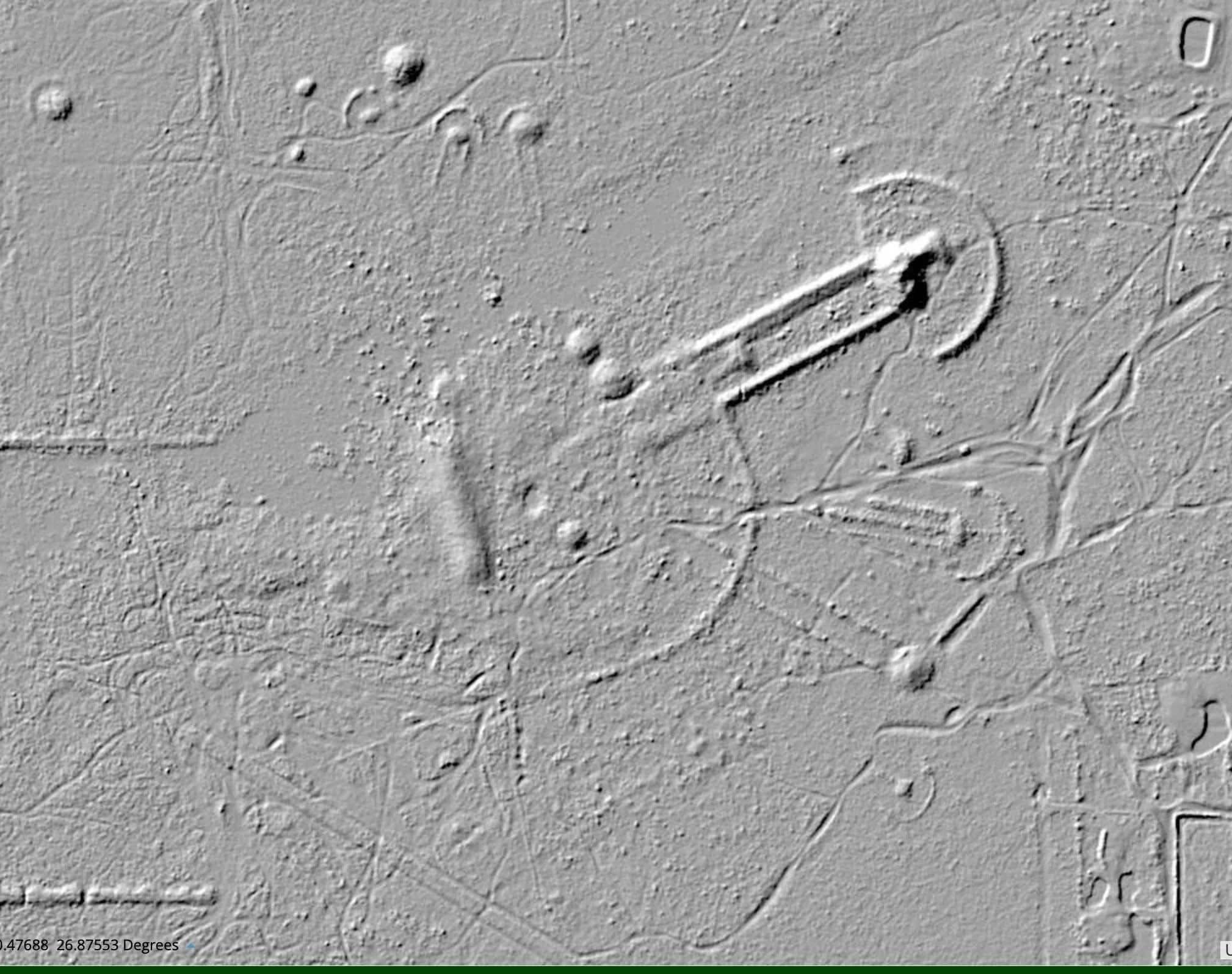
Several factors probably contribute to that obscurity. The site lies in a rural area of southern Florida rather than beside one of the state’s major population or tourism centers, and it has never developed into the kind of heavily interpreted public attraction where visitors encounter museums, reconstructed buildings, extensive trails, and prominent signage. The monumental features can also be difficult to comprehend individually from ground level because their extraordinary organization becomes most apparent when the landscape is considered as a whole or viewed from above.
There is also a broader historical reason: compared with some of Florida’s better-known archaeological traditions, the Belle Glade cultural region received relatively limited public attention and archaeological investigation for many years. Tony’s Mound therefore occupies a strange position in Florida history, because it is physically enormous yet culturally almost invisible to the modern public. That may be one reason the site feels so mysterious, even though there is no need to invent supernatural explanations or lost civilizations to make it fascinating; the actual archaeological story is extraordinary enough.
The Plants of Tony’s Mound
Ross Allen’s early account also contains details that are particularly interesting from the perspective of Florida Seed Bank. When he examined the principal mound, he recorded vegetation including sugarberry, mulberry, papaya, saw palmetto, and other plants growing on or around the elevated ground. Those observations were made in the twentieth century and should not automatically be treated as a botanical inventory of the site thousands of years earlier, but they demonstrate how closely vegetation and topography are intertwined in South Florida.
Elevation changes soil moisture, flooding frequency, fire behavior, and the kinds of plant communities capable of surviving in a particular place. For ancient communities living within the Okeechobee landscape, plants would have been far more than scenery: they provided food, fiber, wood, medicine, shelter, tools, and habitat for animals, while particular trees and plant communities could also indicate wetter or drier ground and reveal subtle differences in a landscape where a few inches of elevation might matter enormously.
Epidendrum floridense: A Living Piece of the Okeechobee Landscape
Growing on trees in portions of South Florida is the Florida star orchid, Epidendrum floridense, an epiphytic orchid native to southern Florida and Cuba. Unlike plants rooted in ordinary soil, epiphytes use trees and other surfaces for physical support while obtaining moisture and nutrients from their surrounding environment rather than feeding parasitically on the host tree.
In Florida, Epidendrum floridense is associated with swamps, sloughs, and hammocks in the Everglades and Lake Okeechobee regions, where it has been documented growing on wetland trees including pond apple and pop ash. Its comparatively understated yellow-green flowers are associated with nocturnal moth pollination, connecting the orchid to yet another component of the South Florida ecosystem. The species is considered endangered in Florida, making it an especially powerful plant with which to connect the ancient and modern Okeechobee landscape.
Florida Seed Bank is not claiming that archaeologists have demonstrated that Epidendrum floridense grew directly on Tony’s Mound while the earthworks were being constructed. The orchid is included because it belongs to the broader South Florida and Lake Okeechobee wetland world in which Belle Glade communities developed, providing a living example of the native flora associated with that greater ecological landscape.
Imagine Lake Okeechobee Before the Canals
To understand Tony’s Mound, it helps to mentally remove much of modern South Florida. Imagine the region before the great drainage projects, before vast agricultural fields occupied former wetlands, before highways crossed areas once inundated for long periods, and before enormous systems of levees, canals, and pumps determined where water could and could not travel.
Lake Okeechobee sits within a much broader watery landscape. Seasonal rainfall sends water outward into marshes and wet prairies, while hammocks and tree islands rise subtly from the surrounding wetlands. Pond apples and wetland hardwoods occupy swamp forests, native orchids cling to branches above dark water, fish move through interconnected aquatic systems, and alligators, turtles, wading birds, deer, and countless smaller animals respond to changing water levels.
Within this landscape, people are building. Families and communities transport soil and sand, adding material to ridges that rise above the surrounding wetland. A curved earthwork gradually expands until it spans hundreds of feet, straight ridges extend away from it at deliberate angles, and mounds grow at significant points in the landscape. What might take us only seconds to comprehend on an aerial photograph could have represented generations of accumulated knowledge, labor, and meaning.
What the Ancient Circles Still Cannot Tell Us
Part of Tony’s Mound’s appeal lies in what remains unknown. Archaeology can establish the presence, form, and relationships of earthworks, examine artifacts and soils, compare sites, reconstruct environmental conditions, and identify compelling patterns in architecture, but it cannot recover every thought, ceremony, or intention of people who lived thousands of years ago.
We therefore do not know the complete meaning of Tony’s Mound’s enormous circle, nor can we say with certainty what every mound represented, what happened in every open space, or whether particular lines carried several meanings at once. Interpretations involving ceremony, seasonal cycles, community gatherings, transportation, settlement organization, and cosmology can be evaluated using archaeological evidence, but mysteries remain, and those unanswered questions make the site more interesting rather than less.
The Landscape Was Part of the Monument
Perhaps the most important lesson of Tony’s Mound is that the archaeological site does not truly end at the edge of an earthwork. The surrounding water, tree islands, animals, plants, seasonal movement of the sun, and cycles of rain all mattered. The landscape was not simply empty space surrounding the monument; it was part of what gave the monument meaning.
This is particularly important today because so much of that surrounding ecological context has been transformed. During the modern era, drainage canals, levees, agricultural conversion, and development radically altered the hydrology of the greater Everglades and Lake Okeechobee systems. Water that once spread gradually across enormous wetlands was redirected, contained, or removed, while plant communities adapted to historic flooding patterns disappeared from many areas.
Archaeological Memory and Genetic Memory
This is where archaeology and seed conservation unexpectedly meet. Tony’s Mound preserves cultural memory in the earth: its ridges, circles, mounds, and causeways are physical traces left by generations of people who inhabited Florida long before the modern state existed. Native plants preserve another kind of memory because surviving populations contain genetic variation produced through generations of adaptation to particular soils, rainfall patterns, flooding regimes, pollinators, diseases, and other environmental pressures.
An endangered orchid such as Epidendrum floridense therefore represents more than an attractive or unusual species. Its surviving Florida populations contain biological information inherited through generations of life in South Florida’s wetlands. In that sense, the earthworks and the plants surrounding them tell parallel stories: one preserves the memory of people, while the other preserves the memory of ecosystems, and both can be lost.
Tony’s Mound preserves cultural memory in the earth, while native plants preserve biological memory in their genes. Protecting Florida means recognizing that both stories belong to the same landscape.
The Circles Remain
Thousands of years after Native Floridians began transforming the Okeechobee landscape, the enormous geometric patterns associated with places such as Tony’s Mound still provoke questions. Why was one ridge placed at one angle and another somewhere else, why construct a curved earthwork hundreds of feet across, and why do some of these monuments appear to engage with seasonal cycles, surrounding water, and other important places across the landscape?
Some answers may eventually emerge through new archaeological techniques, remote sensing, environmental reconstruction, and additional study, while other meanings may have disappeared with the people who understood them best. What remains is enough to overturn the idea that ancient South Florida was merely an untouched wilderness through which small groups wandered without substantially shaping their surroundings. Native Floridians were engineers, architects, builders, and careful observers of the natural world, creating monumental landscapes on a scale that is still capable of surprising us today.
Their achievements were not separate from nature; they were constructed within it. That may ultimately be what makes Tony’s Mound so relevant to conservation today, because the site reminds us that Florida’s natural landscapes are also cultural landscapes carrying the intertwined histories of water, plants, animals, and people.
The ancient people who constructed Tony’s Mound inhabited a Lake Okeechobee region that no longer exists in precisely the form they knew. Much of the hydrology has changed, many wetlands have disappeared, and native plant communities survive in increasingly fragmented places, yet pieces of that Florida remain beneath our feet in ancient ridges and mounds, within wetlands that still flood with the seasons, in the genetic diversity of native plants, and sometimes high on the branch of a South Florida tree where the green flowers of Epidendrum floridense still open in the humid air.
Preserving those pieces allows Florida to retain more than biodiversity. It allows us to preserve fragments of the living landscape that shaped thousands of years of human history, while giving future generations the opportunity to understand both the ancient circles written into the earth and the native species that still carry the biological memory of the world around them.
Sources & Further Reading
- Florida Museum of Natural History — The Belle Glade Monumental Landscape
- The Florida Anthropologist — A Belle Glade Earthwork Typology and Chronology
- Tony’s Mound — overview and references to Ross Allen’s 1948 “The Big Circle Mounds”
- Royal Botanic Gardens, Kew — Epidendrum floridense
- North American Orchid Conservation Center — Epidendrum floridense